About
Location :
Added by Jopie, at 10 December 2017
Opening Hours
- Monday Open 24 hours
- Tuesday Open 24 hours
- Wednesday Open 24 hours
- Thursday Open 24 hours
- Friday Open 24 hours
- Saturday Open 24 hours
- Sunday Open 24 hours
Gallery



Add missing information
17 Reviews
-
06 March 2019
Wonderful trail. getting much popular among the travellers
response / report this review -
06 March 2019
With my personal experience, I would say the best trail to sri padaya.
It would take nearly 15 hours to reach the top. Road is not so easy but the surrounding is beautiful and you can feel clean air and nice views in the forest.
Best time to start is around 4 pm from Kuruwita with a great view.
You need to have torches even there electric lights located along the way. Take light backpacks as at some points you have to climb straight up and heavy backpacks would make it difficult.
On each 2-3 km, shops and places to stay are available.response / report this review -
03 March 2019
Awesome treck. The trail is lit up all the way if you're trecking at night. Can get to the top in 9 hours.
response / report this review -
16 February 2019
Beautiful sceneries, not at all polluted by garbage. Tough terrain though. 14KM hike through wilderness.
response / report this review -
15 February 2019
The most beautiful route among the most ppl going routes.
response / report this review -
13 February 2019
This tail is the longest tial in other tails in sisipada. This tail is 14km long it like tuwice long than hatton tail. This tail is the most beautiful tail. In this tail is not a well build one. Only some place have only small path only. In this tail we can found more and more water spots we can use to drink. That water is very good other tails. All are natural. This tail is not harmful for environment. Because This tail not have cement blocks or stairs. This path is environmental friendly. But this tail is hard. Some palace have large water path hard to crossing while raining. This path suitable for youngers. This tail dont have bridge for cross the seetha gagula river. You must cross the river using your leges. But raining is dangerous for this crossing because water level is going high quickly. In this tail have little number of shops. Price is smaller than other tails. But this parth is best. Try it. Enjoy it. But do eny harm for environment. Don't put waste environment.
response / report this review -
09 February 2019
This is the most strenuous and the longest trail from the main 3 trials. Concrete steps are very much limited. Most of the trial is with rugged and natural steps. Not recommend for first time travelers who are do not have hiking experience. Total distance is 10-12 km.
response / report this review -
29 January 2019
The ancient trail to Sri Pada. Paved road available till the car park with security. you may find some walking sticks at an end of the car park where earlier hikers left or you can buy a well crafted walking stick. 40 min from Kuruwita town (High Level Road).
Trail is 12 km long and will take about 15 hours with normal walking speed to reach the top. Elevation Gain is 1.85 km.
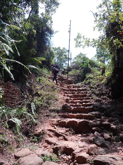
The first 3.4km of this trail is mostly an intense continuous climb. There will be brief flat or less intense sections, but they rarely last for more than 100m at a stretch. This section of the trail mostly goes through the disturbed forest and abandoned tea fields and therefore the trail is fairly broad and open. Steps and other forms of support is available only at most difficult point. The rest of the trail is a rough track over boulders and rocks for the most part.
This climb ends at the top of a mountain known as "Warnagala" meaning "The colourful rock". "Warnagala" possibly got its name because of the large, exposed rock bed on its side. A stream flows over the large rock bed creating a beautiful large waterfall called "Warnagala falls". Unfortunately at present most of the water have been diverted to generate hydro power and therefore the true beauty of the fall can only be seen during the wet months (off season).
Following are resting places available on the way.
"Jambolagaha-Yata" Ambalama (A Permanent Rest Place) at 1.6km from trail head
"Diamondgala" ambalama (A Permanent Rest Place) at 2.6km from the trail head
The intake basin of the penstock of the power plant (where the large pipes carrying water to the turbines collect water diverted from the stream) at 2.8km from the trail head
"Saman Dewalaya" & Buddha Statue about 50m after the above waypoint.
Passing "Haramitipana Plain" you have to tackle a somewhat intense and continuous climb on an irregular rocky trail for about 1.2km to reach the last permanent resting place before the summit which is called "Adiyamalathenna" (Waypoint: ES35)
From this point the steepest ascend of the trail has to be tacked. This section is called "Mahagiridamba" or "The Great Rock Climb". This entire 800m of length is a steep climb. The last 600m is so steep that the steps are continuously aided with steel bars on both sides. As you reach the summit it feels more like walking in the Sky as the steps are so steep.
Special Note:
The summit can be extremely windy & cold, be prepared if you plan to stay there for a considerable time.
Except during the late months of Sripada season, the probability of rain is quite high. (Thunder storms during monsoon months May – July, Sep – Nov). Be prepared with a rain coat and water proofing for electronics such as cameras.
Leaches may occasionally bother you, especially in the lower sections of the trail.
Small shops pop up on the way to the mountain top offering all sorts of food and refreshments during Sripada season.
Drinking Water is plentiful. Water from streams is generally safe to drink without treatment.
Make it a point to be at summit before sunrise to witness how the distinctive shape of the mountain casts a triangular shadow on the surrounding plain.
The best approach would be to start from the trial head on a late morning, reach “Galwangediya” or "Heramitipana" by the evening, spend the night there and climb up to the summit before the sunrise.
The sheltered rest spots or "Ambalamas" are suitable for an overnight stay if required. During Sripada season, the trail is lit-up at night. But better to have some kind of light as there are some dark areas.response / report this review -
15 January 2019
A Wonderful road to Sripadaya Please do not bring polythene bags and plastic bottles.
response / report this review -
09 January 2019
It is the best hiking route to Sri pada. Cleaner than the Hatton route and you will be able to vitness the beautiful warnagala water fall.
response / report this review -
17 March 2018
Most beautiful n longest path to sri paadaya. Great..
response / report this review -
04 March 2018
One of the most relaxing and enjoyable foot path to the Sri Paada. Few sections are steep. But overall not hard to travel. A quick detour to the right at Warnagala leads to a nice waterfall where you can have a swim in the natural pools.
response / report this review -
10 February 2018
Amazing trail .. superb view trail is about 23 km but worth every inch..
response / report this review -
04 February 2018
Longest path to the Sripada. Not all the way has stairs. It's better and somewhat easy to come down than the stairs. First few kilometers has several water streams. Not much shops to buy food or a tea. Bring everything you need.
Trail is very difficult upto Heramitipana. After join with ratnapura trail, it's not that much difficult.
Be prepared for rains and freezing cold.
It's a sacred place. You are bound to protect the tradition. And also the nature.response / report this review -
03 February 2018
The longest route to the sacred holy mountain (Sri Pada - The Lord Buddha's footprint) . Elevation gain is 1800 m. The climb is not steep, there are many flat sections abound. Some sections of the road are strewn with large rocks where it could be strenuous to climb.
response / report this review -
19 January 2018
Trail Difficulty: Easy | Moderate | Strenuous | Tough
Trail Head: Adevikanda, Erathna (near entrance to mini-hydro power plant)
Nearest Town: Erathna Nearest City: Kuruwita
Access to Trail head:
Route to Adevikanda, Erathna
Colombo -> Awissawella -> Ehaliyagoda -> Kuruwita Town [80km] -> Erathna[11km] -> Adevikanda[3km] (approximately 94km)
Roads are paved all the way up to the trail head from the Kuruwita town on A4 Highway. Public transport is available from Kuruwita to the trail head during the Sri Pada season. Off season this will be limited to the Erathna town. Account for 40 mins from Kuruwita if driving and 1.5 hours on public transport.
Trail End: Sripada (Adam's peak) Total Length: 12km
Elevation Gain: 1850m (Elevation at Trail Head: 400m | Elevation at Trail End: 2250m)
Approximate time: 8 – 12 hours
Hiking Season: Official Sri Pada season begins in December and ends in April. This is the period of best weather. Avoid long week-ends and full-moon days during this period unless you enjoy a crowded trailJ.
An off-season climb can also be extremely rewarding since you will completely be away from any civilization or human contact until you reach the peak. Select a dry moth, July or August, since the trail can be extremely hazardous to pass during monsoon months.
Permit Required: NO
Kuruwita – Erathna trail to Sri Pada is the third most popular trail leading to Adam's peak. This trail is much difficult to tackle than the most popular Hatton-Nallathanni route.
While this trail is about 3km longer than the second most popular Rathnapura – Palabathgala route, the trail conditions and the surrounding environment is very much similar to the Palabathgala trail. In fact these two trails meet 2km before the summit.response / report this review -
17 December 2017
This where Lord Buddha kept his foot print during his visit to Sri Lanka after requested by God Sumana Saman. This place is a good hike for about 4-6hrs and normally people start hiking in the evening as when they reach the top it will be the sun rising time. Which can be seen nicely..
response / report this review