About
Location :
Added by Jopie, at 08 May 2017
Gallery


Add missing information
8 Reviews
-
07 April 2018
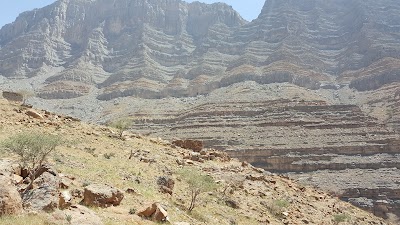
The beginning of a famous trail Wadi Shah. This has to be done with the help of someone who did this or a proper downloaded trail because the trail is unmarked before midway of the loop and there is a good chance you can get lost over the top with out water or any help. The trail is beautiful and equally dangerous because of the steep rocks or loose rocks. This route is now becoming commercial and lots of trekking groups are organising this trek. Better to go there in colder months when the temperature is below 30 degrees.
response / report this review -
30 March 2018
not good for camping to many people coming late at night and play loud music and no restaurant in the place
response / report this review -
11 March 2018
Lovely trail, not for beginners. There's a number of routes but they're not marked, make sure you have proper guide who knows the area or download a trail.
response / report this review -
25 February 2018
The highest mountain in UAE. Most of the time it's cold and it snow some time during the winter.
response / report this review -
10 January 2018
Tried some distance to climb.. it was too good
response / report this review -
25 November 2017
THIS IS PART OF WADI SHIHA TRAIL LOOP CAN BE CHALLENGING YOU NEED TO KEEP GPS WITH TRAIL IN CASE YOU LOSS THE WAY. ESPECIALLY IN THE UPPER VILLAGE FORWARD TO THE FULL CIRCUIT
response / report this review -
09 July 2017
There are several ways to tackle the trail as there are several of them. They are loosely marked so beware of getting lost. I am more acquainted with the left loop trail as i have done that twice and would like to do that again if i have the chance. The best time to climb is in the cooler months from November to March. September & April will be very challenging, May is torture and the rest of the other months for a hobbyist will be suicide. Summer heat can go beyond 40 in the shade. The whole loop can be done in a day if you know the trail well. You can also do a boomerang by doing the hard rock trail going up to a place i call "Highway", a spot in the ravine that look like a paved road which is actually a large sheet of rock shaped by water (Check my pictures to identify it. It can't be missed if this specific trail is followed as it is the only large flat area to walk on) and then u-turn to the easy path on the way back. The "Highway" is a about 1/3 of the full loop and 1/2 of the climbs. Either way, expect the full trek to take about 10 hours for the novice or maybe even more. The place is spectacular and if not careful, extremely dangerous. We were told by the shepherds that already on 2 separate occasions, helicopters airlifted injured hikers. Paths are steep, loose and offers no cover from the sun. Rocks and plants both bite with their pointy sharp parts and there is no water fit for drinking unless you bring it in yourself. I do not recommend filtering water along the way as it may contain high amounts of dissolved feces plus salt & minerals from the rocks. There are both wild and farm animals wandering about and it would be better to stay away from all of them. Be cordial to the locals that you meet. They are very friendly and are your best bet for immediate help if you get into trouble but refrain from taking photos of them without permission. Final notes, It is best to not hurry (mainly for safety) but rather to enjoy the trail as there are a lot of unusual things to see if you do; like the huge boulder that is split in the middle with a smaller rock (a.k.a. Samson and the temple), the falcons beak outcrop, small caves, "The garden of Eden" and so on. Start early and if you do not reach the "Highway" by 11:30 A.M., turn around and walk back if you do not plan to stay for the night. Good luck and have fun!
response / report this review -
15 May 2017
Must see
response / report this review